Local Government
East Pilbara
Region
Pilbara
34 km W on Six Mile Creek Marble Bar
East Pilbara
Pilbara
| Type | Status | Date | Documents |
|---|---|---|---|
| (no listings) |
| Type | Status | Date | Documents |
|---|---|---|---|
| RHP - To be assessed | Current | 25 Aug 2006 |
| Type | Status | Date | Grading/Management | |
|---|---|---|---|---|
| Category | ||||
| Register of the National Estate | Indicative Place | |||
| Classified by the National Trust | Classified {Lscpe} | 01 Jun 1995 | ||
Strelley Pool Chert has great value to the scientific community, for whom it represents evidence for the earliest phase of life on Earth. This value has been demonstrated in June 2006, by calls from prominent Australian scientists for protection to be afforded to the site. Strelley Pool Chert has value to the scientific community as a source of information that can provide information about life on other planets, including Mars.
Strelley Pool contains some of the best-preserved and most widespread exposures of stromatolites, which are evidence for the earliest known life on Earth. The place is in a picturesque gorge section of the Pilbara region. The approximately 3420 million-year-old Strelley Pool Chert is a laminated grey and white unit within the Warrawoona Group, Pilbara Supergroup, which is part of the East Pilbara Granite-Greenstone Terrane in the Pilbara Craton. The Strelley Pool Chert is typically 30m thick and consists of a basal sandstone unit, middle unit of carbonate that is largely affected by later silicification, and an upper unit of sandstone and conglomerate. Stromatolites have been found in the carbonate and upper sandstone units, and include steep-sided conical forms and rare branching forms.
It is thought that the stromatolites were developed in a very shallow, hyper-saline water body. The stromatolitic communities probably consisted of filament like, light responsive forms that may have been capable of moving to light through a gliding movement. Their existence was essential for later developments, as the micro-organisms slowly produced the oxygen that allowed higher organisms to develop almost two billion years later.
| Library Id | Title | Medium | Year Of Publication |
|---|---|---|---|
| 2398 | National Estate Program : documentation of geological sites and monuments; Nomination of geological monument for the register of the National Estate: Dingo Gap, Bugle Gap, Bringo Railway cutting, Molecap Hill, Veevers Crater, Dalgaranga Crater, North Pole, | Report | 1989 |
| 1180 | Strelley pool west | Report | 1995 |
Geological monument
| Epoch | General | Specific |
|---|---|---|
| Original Use | OTHER | Other |
| Present Use | SOCIAL\RECREATIONAL | Other |
| General | Specific |
|---|---|
| DEMOGRAPHIC SETTLEMENT & MOBILITY | Environmental change |
This information is provided voluntarily as a public service. The information provided is made available in good faith and is derived from sources believed to be reliable and accurate. However, the information is provided solely on the basis that readers will be responsible for making their own assessment of the matters discussed herein and are advised to verify all relevant representations, statements and information.
35.8km NW from Marble Bar
East Pilbara
Pilbara
| Type | Status | Date | Documents |
|---|---|---|---|
| (no listings) |
| Type | Status | Date | Documents |
|---|---|---|---|
| (no listings) |
| Type | Status | Date | Grading/Management | |
|---|---|---|---|---|
| Category | ||||
| Register of the National Estate | Nominated | 11 Jan 1991 | ||
| Classified by the National Trust | Classified {Lscpe} | |||
Geological monument
| Epoch | General | Specific |
|---|---|---|
| Original Use | OTHER | Other |
| Present Use | OTHER | Other |
This information is provided voluntarily as a public service. The information provided is made available in good faith and is derived from sources believed to be reliable and accurate. However, the information is provided solely on the basis that readers will be responsible for making their own assessment of the matters discussed herein and are advised to verify all relevant representations, statements and information.
40km from Mt Edgar Homestead Marble Bar
and adjacent to the Nullagine River
East Pilbara
Pilbara
| Type | Status | Date | Documents |
|---|---|---|---|
| (no listings) |
| Type | Status | Date | Documents |
|---|---|---|---|
| (no listings) |
| Type | Status | Date | Grading/Management | |
|---|---|---|---|---|
| Category | ||||
| Register of the National Estate | Nominated | 13 Aug 1990 | ||
| Classified by the National Trust | Classified {Lscpe} | |||
| Library Id | Title | Medium | Year Of Publication |
|---|---|---|---|
| 5921 | Off-shears : the story of shearing sheds in Western Australia. | Book | 2002 |
Geological monument
| Epoch | General | Specific |
|---|---|---|
| Original Use | OTHER | Other |
| Present Use | OTHER | Other |
This information is provided voluntarily as a public service. The information provided is made available in good faith and is derived from sources believed to be reliable and accurate. However, the information is provided solely on the basis that readers will be responsible for making their own assessment of the matters discussed herein and are advised to verify all relevant representations, statements and information.
50 Augusta St Marble Bar
CWA Centre
G J W G Miles House
East Pilbara
Pilbara
Constructed from 1909
| Type | Status | Date | Documents |
|---|---|---|---|
| State Register | Registered | 17 Nov 2006 | HCWebsite.Listing+ListingDocument, HCWebsite.Listing+ListingDocument |
| Type | Status | Date | Documents |
|---|---|---|---|
| (no listings) |
| Type | Status | Date | Grading/Management | |
|---|---|---|---|---|
| Category | ||||
| Municipal Inventory | Adopted | 27 Aug 1999 | ||
| Restrictive Covenant | YES | |||
| Register of the National Estate | Indicative Place | |||
| Classified by the National Trust | Classified | 03 Sep 1984 | ||
| Register of the National Estate | Nominated | 19 Apr 1985 | ||
Good
| Library Id | Title | Medium | Year Of Publication |
|---|---|---|---|
| 7206 | CWA House (former G,J,G.W. Miles house) : Architectural evaluation for the Western Australian Heritage Committee. | Heritage Study {Other} | 1987 |
| 7211 | Images CD No. 36 : assessment images : Church of St Mary Star of the Sea Group, Carnarvon; Poinciana House, Marble Bar; Corunna Downs Station & Wartime Airbase; Gascoyne Research Station, Carnarvon. | C D Rom | 2004 |
Individual Building or Group
| Epoch | General | Specific |
|---|---|---|
| Original Use | RESIDENTIAL | Single storey residence |
| Other Use | SOCIAL\RECREATIONAL | CWA Hall |
| Present Use | RESIDENTIAL | Single storey residence |
| Style |
|---|
| Federation Bungalow |
| Type | General | Specific |
|---|---|---|
| Roof | METAL | Corrugated Iron |
| Wall | STONE | Local Stone |
| General | Specific |
|---|---|
| OCCUPATIONS | Domestic activities |
| PEOPLE | Local heroes & battlers |
| SOCIAL & CIVIC ACTIVITIES | Institutions |
This information is provided voluntarily as a public service. The information provided is made available in good faith and is derived from sources believed to be reliable and accurate. However, the information is provided solely on the basis that readers will be responsible for making their own assessment of the matters discussed herein and are advised to verify all relevant representations, statements and information.
Constructed from 1909, Constructed from 1908
Poinciana House has aesthetic, historic, and social qualities valued by the community and has significant heritage value. The house is significant not just for its solid construction and gracious appearance . but also for its association with George Miles who was a Member of the Legislative Council representing the North Province. Poinciana House has been classified by the National Trust, and is on the Register of the National Estate.
Poinciana House stands on the corner of two streets with wide verges. The terrain in the immediate vicinity is flat but further afield it is undulating to hilly. The surrounding residences are mainly framed and fibro cottages. The building is not part of a historic precinct and the general condition of the building is sound. The walls are rough dressed granite, lime mortar with rough lime mortar pointing, lined in random block pattern with indented lines originally painted black. Window surrounds are dressed with cement rendered quoins. The hipped tin roof extends out over the wide cement verandahs and is supported by steel upright posts. The house has rural colonial features: single storey, wide verandah protecting all walls, iron roof with simplistic lines.
Poinciana House was built between 1908-09 for George James Gallop Warden Miles, the work being done by day labour. It is one of the few masonry buildings in Marble Bar, most of the structures in the town being of frame and sheet clad construction. The stonework was constructed by a craftsman called Jerred. Mrs Miles appreciated her beautifully built home and planted a garden of poinciana trees and lawn around the house. The house was described as "a beauty spot and an oasis in the hot town of Marble Bar". (Gold Dust & Iron Mountains, p. 15.) A letter written to the CWA in 1980 by the daughter of Mr and Mrs Miles, Mrs Valentine, gives a beautiful picture of her life experiences in Poinciana House (p. 154 of Gold Dust and Iron Mountains). The house is associated with George Miles, who was an astute businessman, owning stores and hotels across the Pilbara. His businesses were taken over by his son, George Miles Jnr. In the 1960s Miles sold Poinciana House to the Johnson family. Soon after, in 1967, the CWA acquired it and ran their Association from the premises for nearly 20 years. In July 1935, 17 ladies had gathered at the house of Mrs Claude Martin to form the Marble Bar CWA branch (then the most northerly in WA). The CWA work included fiindraising for a rest house in Port Hedland for Marble Bar pregnant ladies, waiting to have their babies in the Port Hedland Hospital. Donations also went to the Flying Doctor Service and the Red Cross. In the 1940s the CWA first rented, then bought the home of Thomas Byass, and in 1967 bought Poinciana House. Peter and Jean Glover bought the house in 1991 and appear to have retained the historical name 'Poinciana House', though new poinciana trees had to be planted as the old ones were eaten by white ants. A restoration plan has been drawn up.
| Name | Type | Year From | Year To |
|---|---|---|---|
| George Miles | Architect | 1908 | 1909 |
| Ref ID No | Ref Name | Ref Source | Ref Date |
|---|---|---|---|
| H Edwards; "Gold Dust and Iron Mountains". p.15 &154 | 1993 | ||
| Architectural Evaluation for the WA Heritage Committee | 1987 | ||
| Royal Aust. Institute of Arch. Advisory Service |
This information is provided voluntarily as a public service. The information provided is made available in good faith and is derived from sources believed to be reliable and accurate. However, the information is provided solely on the basis that readers will be responsible for making their own assessment of the matters discussed herein and are advised to verify all relevant representations, statements and information.
The house is one of the few masonry buildings in Marble bar, most of the structures in the town being of frame and sheet clad construction The plan form is unusual and no doubt was an innovative attempt to deal with the hot conditions of the town (reputed to be the hottest town in the country). The stone work and cement rendered quoins are of high quality workmanship. The historic significance lies in its age, having been built in 1908 in relation to the declaration of the town in 1893 and its association with a prominent figure, George James Gallop Warden Miles, Member of Parliament and prominent publican. Mr Miles represented the North Province in the Legislative Council from 1917 to 1950 and was publican at various times of the following hotels: Iron Clad, Marble Bar, Coongan Pub, Colligong Pub and Conglomerite.
Walls of local stone and roof of corrugated galvanised iron held down with cyclone battens. The plan consists of a cruciform passage dividing the square central core into the four rooms and opening into a large lobby at the intersection of the cruciform. Verandahs which are on all sides of the central core are supported on steel columns and have concrete floors. The house was built for George James Gallop Warden Miles. The work was done by day labour and took six years to finish.
Construction 1908
This information is provided voluntarily as a public service. The information provided is made available in good faith and is derived from sources believed to be reliable and accurate. However, the information is provided solely on the basis that readers will be responsible for making their own assessment of the matters discussed herein and are advised to verify all relevant representations, statements and information.
Bamboo Creek Rd Marble Bar
East Pilbara
Pilbara
Constructed from 1892
| Type | Status | Date | Documents |
|---|---|---|---|
| (no listings) |
| Type | Status | Date | Documents |
|---|---|---|---|
| (no listings) |
| Type | Status | Date | Grading/Management | |
|---|---|---|---|---|
| Category | ||||
| Municipal Inventory | Adopted | 27 Aug 1999 | ||
Individual Building or Group
| Epoch | General | Specific |
|---|---|---|
| Present Use | MINING | Other |
| Original Use | MINING | Other |
| Type | General | Specific |
|---|---|---|
| Wall | STONE | Other Stone |
| General | Specific |
|---|---|
| OCCUPATIONS | Mining {incl. mineral processing} |
This information is provided voluntarily as a public service. The information provided is made available in good faith and is derived from sources believed to be reliable and accurate. However, the information is provided solely on the basis that readers will be responsible for making their own assessment of the matters discussed herein and are advised to verify all relevant representations, statements and information.
Constructed from 1892
These mining relics have historic significance, representing an era of mining activity in the district in the 1890s. Bamboo Creek became a gold mining town and at that time there were enough people resident there to warrant a separate Roads Board being formed.
The mining relics at Bamboo Creek are located in an isolated bush setting. Evidence of seam mining in the hillside can be seen while the relics are scattered around the site. A stone building still stands after many decades. However, it has no roof and is quite badly dilapidated. The stonework in the walls reflects the effort put in by the Byass brothers for these living quarters, which were situated near their Bulletin Mine. Another coirugated iron building is in better condition. The remnants of a ten stamp battery can be seen nearby.
Bamboo Creek became a gold mining town during the 1890s. Gold was found in Bamboo Creek before the finds at Marble Bar, but then development took similar patterns - a minor gold rush and the stayers settling in to develop eight prosperous mines. In June 1893 the population of the combined Bamboo Creek/Marble Bar goldfleld was 200. In 1892 Bamboo Creek's first mining battery was installed. It was owned and operated by the Byass Brothers (Thomas and Percy). It is believed to have been the first privately owned battery in WA. The first ore crushed came from the Bamboo Queen Mine. The Byass brothers expanded their holding by buying the Bulletin Mine. By 1896 Bamboo Creek had grown enough to command its own Roads Board, independent from the Pilbara Roads Board. At the Bulletin Mine the substantial stone building was erected for living quarters. The walls still stand today. A 10 stamp battery was brought to the site but the exact location of the original battery is not known.
| Ref ID No | Ref Name | Ref Source | Ref Date |
|---|---|---|---|
| H Edwards; "Gold Dust and Iron Mountains". | Beyond | 1993 | |
| K Mallett; "To the Bar Bonded". | 1992 |
This information is provided voluntarily as a public service. The information provided is made available in good faith and is derived from sources believed to be reliable and accurate. However, the information is provided solely on the basis that readers will be responsible for making their own assessment of the matters discussed herein and are advised to verify all relevant representations, statements and information.
Camel Creek Marble Bar
16km S of Marble Bar
Camel Creek Geological Site
East Pilbara
Pilbara
| Type | Status | Date | Documents |
|---|---|---|---|
| (no listings) |
| Type | Status | Date | Documents |
|---|---|---|---|
| (no listings) |
| Type | Status | Date | Grading/Management | |
|---|---|---|---|---|
| Category | ||||
| Classified by the National Trust | Classified {Lscpe} | 27 Sep 1991 | ||
| Register of the National Estate | Indicative Place | |||
| Library Id | Title | Medium | Year Of Publication |
|---|---|---|---|
| 2347 | Camel Creek : nomination of a geological monument for the register of the National Estate. | Book | 1991 |
Geological monument
| Epoch | General | Specific |
|---|---|---|
| Present Use | OTHER | Other |
| Original Use | OTHER | Other |
| General | Specific |
|---|---|
| SOCIAL & CIVIC ACTIVITIES | Education & science |
This information is provided voluntarily as a public service. The information provided is made available in good faith and is derived from sources believed to be reliable and accurate. However, the information is provided solely on the basis that readers will be responsible for making their own assessment of the matters discussed herein and are advised to verify all relevant representations, statements and information.
Francis St Marble Bar
Includes: Ironclad Hotel Formerly also included Marble Bar Liquor & General Store, but this was destroyed by fire in Nov 2004, subsequently demolished, and is no longer in the curtilage.
Hotel & Store Group - prior to fire at Store
Osborn's Hotel/Walter's Hotel/Osborn Parlour
East Pilbara
Pilbara
Constructed from 1892 to 1966
| Type | Status | Date | Documents |
|---|---|---|---|
| State Register | Registered | 17 Nov 2006 | HCWebsite.Listing+ListingDocument, HCWebsite.Listing+ListingDocument |
| Type | Status | Date | Documents |
|---|---|---|---|
| (no listings) |
| Type | Status | Date | Grading/Management | |
|---|---|---|---|---|
| Category | ||||
| Municipal Inventory | Adopted | 27 Aug 1999 | ||
Damaged during a cyclone in 1999; General Store completely destroyed by fire 27/11/04, debris subsequently removed to clear site. Ironclad Hotel, Marble Bar is generally in fair condition, although there is extensive evidence of termite damage. The termite damage is extensive, and can be seen in the main bar area door frames and the ablution block, in particular the timber stud frames, door frames and ceiling timbers. The accommodation facilities show extensive damage to walls and ceilings, and the dwelling facility has a collapsed ceiling and extensive damaged timbers.
| Library Id | Title | Medium | Year Of Publication |
|---|---|---|---|
| 9761 | Ironclad Hotel, Marble Bar | Heritage Study {Cons'n Plan} | 2011 |
| 9268 | Ironclad Hotel, Marble Bar. | Conservation works report | 2009 |
Individual Building or Group
| Epoch | General | Specific |
|---|---|---|
| Original Use | COMMERCIAL | Hotel, Tavern or Inn |
| Present Use | COMMERCIAL | Hotel, Tavern or Inn |
| Original Use | COMMERCIAL | Shop\Retail Store {single} |
| Style |
|---|
| North-West Vernacular |
| Type | General | Specific |
|---|---|---|
| Roof | METAL | Corrugated Iron |
| Wall | METAL | Corrugated Iron |
| General | Specific |
|---|---|
| OCCUPATIONS | Hospitality industry & tourism |
| DEMOGRAPHIC SETTLEMENT & MOBILITY | Resource exploitation & depletion |
| OCCUPATIONS | Commercial & service industries |
| SOCIAL & CIVIC ACTIVITIES | Sport, recreation & entertainment |
This information is provided voluntarily as a public service. The information provided is made available in good faith and is derived from sources believed to be reliable and accurate. However, the information is provided solely on the basis that readers will be responsible for making their own assessment of the matters discussed herein and are advised to verify all relevant representations, statements and information.
Constructed from 1892
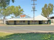
The heritage significance of the Ironclad Hotel lies in its historical and social contributions to the development of the Marble Bar community. The Ironclad Hotel is historically significant as the site of one of the first two permanent buildings erected in the Marble Bar Townsite. It has been the hub of the town from the gold rush era until today. It is the famed setting for many colourful characters, notorious pranks, tall stories, lost fortunes, happy celebrations and memorable wakes. The Ironclad Hotel is synonymous with Marble Bar. Across the nation one mentions one name and gets the other as the response. It has an unbroken link with many eras of rich history.
The Ironclad Hotel on lots 15 and 16 of Marble Bar townsite is a complex of buildings of various styles and ages with frequent additions and renovations over the years. The hotel is situated on the main road of Marble Bar and is a significant landmark in the town.The building has a corrugated iron roof with corrugated iron walls.
There is no doubt that a hotel has traded continually from this site since 1892 and records reveal that it has traded under the name Ironclad Hotel since November, 1893. The Hotel has always incorporated a public bar and verandah on the Francis Street frontage and efforts have been made to maintain some integrity of design with early Hotel photographs. It is highly likely that the Hotel was named after the richest reefing claim then, the Ironclad Lease, which had been granted in that name in November. 1891. (SAWA Mines Dept.,Cons 4136.) The hotel was one of only two permanent structures noted by E N Geyer on 15/3/1893 on Marble Bar townsite sketches
| Ref ID No | Ref Name | Ref Source | Ref Date |
|---|---|---|---|
| K Mallett; "To the Bar Bonded". pp.27-32 | 1992 |
This information is provided voluntarily as a public service. The information provided is made available in good faith and is derived from sources believed to be reliable and accurate. However, the information is provided solely on the basis that readers will be responsible for making their own assessment of the matters discussed herein and are advised to verify all relevant representations, statements and information.
Francis St Marble Bar
East Pilbara
Pilbara
Constructed from 1993
| Type | Status | Date | Documents |
|---|---|---|---|
| (no listings) |
| Type | Status | Date | Documents |
|---|---|---|---|
| (no listings) |
| Type | Status | Date | Grading/Management | |
|---|---|---|---|---|
| Category | ||||
| Municipal Inventory | Adopted | 27 Aug 1999 | ||
Other Built Type
| Epoch | General | Specific |
|---|---|---|
| Present Use | MONUMENT\CEMETERY | Grave |
| Original Use | MONUMENT\CEMETERY | Grave |
| Type | General | Specific |
|---|---|---|
| Wall | BRICK | Common Brick |
| General | Specific |
|---|---|
| PEOPLE | Local heroes & battlers |
This information is provided voluntarily as a public service. The information provided is made available in good faith and is derived from sources believed to be reliable and accurate. However, the information is provided solely on the basis that readers will be responsible for making their own assessment of the matters discussed herein and are advised to verify all relevant representations, statements and information.
Constructed from 1993
The Memorial to the Lonely Graves is important to the heritage of Marble Bar because of its intrinsic, historic and social values. In this one memorial, the Marble Bar community is left with a permanent reminder of the pioneer fortitude that led to the settlement of the district.
The Memorial to the Lonely Graves is located in the main street of Marble Bar in an open park area between the Shire offices and the General Store. The two brick walls that make up the Memorial stand at 120° to one another, with plaques recording the name and date of every person whose grave has been discovered.
This Memorial is a result of passionate and extensive research by Len Lever of Marble Bar. Over the years Len Lever worked on the maintenance of the town water supply, serviced the power house and drove earthmoving equipment for road building. It was the latter job that led him to the lone graves. One day he disturbed a lone grave, that of William Breen died 10/7/24. He found from other grader drivers they had had similar experiences. Len was haunted by the isolation and poignancy of the graves and so he set out "recording, photographing and restoring them". This was followed by the building of a Memorial in the Marble Bar townsite in 1993. The Memorial is a tribute to the many pioneers who came to the harsh land of the Pilbara goldfields in search of a new life. The country and climate were very hard and cruel with the consequence that many people died and were buried in unmarked graves or unnamed graves, marked only by a group of rocks or a stick.
| Ref ID No | Ref Name | Ref Source | Ref Date |
|---|---|---|---|
| H Edwards; "Gold Dust and Iron Mountains". | Beyond | 1993 | |
| Information from Len Lever. Marble Bar |
This information is provided voluntarily as a public service. The information provided is made available in good faith and is derived from sources believed to be reliable and accurate. However, the information is provided solely on the basis that readers will be responsible for making their own assessment of the matters discussed herein and are advised to verify all relevant representations, statements and information.
Lot 14B Francis St Marble Bar
Destroyed by fire in 2004. Originally part of P3954, removed from curtilage after fire.
East Pilbara
Pilbara
Constructed from 1914
| Type | Status | Date | Documents |
|---|---|---|---|
| (no listings) |
| Type | Status | Date | Documents |
|---|---|---|---|
| (no listings) |
| Type | Status | Date | Grading/Management | |
|---|---|---|---|---|
| Category | ||||
| Municipal Inventory | Adopted | 27 Aug 1999 | ||
Extensive white ant damage. Destroyed by fire in November 2004.
| Library Id | Title | Medium | Year Of Publication |
|---|---|---|---|
| 4480 | Marble Bar Liquor & General Store: conservation plan. | Heritage Study {Cons'n Plan} | 2000 |
Individual Building or Group
| Epoch | General | Specific |
|---|---|---|
| Original Use | COMMERCIAL | Shop\Retail Store {single} |
| Type | General | Specific |
|---|---|---|
| Roof | METAL | Corrugated Iron |
| Wall | METAL | Corrugated Iron |
| General | Specific |
|---|---|
| PEOPLE | Early settlers |
| DEMOGRAPHIC SETTLEMENT & MOBILITY | Settlements |
| OCCUPATIONS | Commercial & service industries |
This information is provided voluntarily as a public service. The information provided is made available in good faith and is derived from sources believed to be reliable and accurate. However, the information is provided solely on the basis that readers will be responsible for making their own assessment of the matters discussed herein and are advised to verify all relevant representations, statements and information.
Constructed from 1914
The Marble Bar Store has aesthetic, historic and social significance. It has architectural importance as an example of an early outback building in the Federation style. It is one of the few historic buildings left in Marble Bar dating from the early part of this century [Government Buildings, Ironclad Hotel, the General Store, Roman Catholic Church and Poinciana House (CWA House)]. They all contributed to the historic commercial streetscape of Marble Bar and are the only surviving structures from this era. The General Store has enormous social value to the community who would like to see the place restored as it was originally.
The General Store is a jarrah framed structure with corrugated iron roof and wall cladding and a front verandah. The building was constructed in three sections, the front with simple ridge roof with two rear wings at right angles to the main building. All spans are narrow. In the 1970s the internal posts were removed and a steel girder inserted to support the internal roof, due possibly to white ant damage which has been extensive. The earlier shop fittings have been removed as well as some decorative detailing. From a recent architectural report, it would seem that the historic building fabric could be lost if white ant damage is not arrested.
The original General Store was built around 1893 by Hardie & MacKinnon Bros as part of a historic group of buildings which include the Government Buildings, (1897), Iron Clad Hotel (1894), the butcher shop (1894, rebuilt 1950s 60s) and former cafe (1900, rebuilt 1970s). The original owners were also granted a wine and liquor licence called the Gallon Licence to run in conjunction with the store. The liquor section of the store is still operating on the premises and is contemporary with the Iron Clad Hotel (1894) which is located opposite the store. This replacement store building was constructed in 1914 by J Fawcett operating under Walker and Co. The store was associated with C A N McDonald, who took over the business in 1897 and introduced his own paper money called 'shin plaster' in 1898 to be used in lieu of cash by the gold prospectors. Records and photos of the money exist in the Battye library. A later owner was John Fawcett who took over the business from J M Walker and is responsible for rebuilding the earlier shop in 1914 to include the latest design in shop layout and interior fitout. Fawcett also introduced the forst motor lorry into the area for merchandise haulage in competition with the Afghan camel teamsters. In 1916 G W Miles purchased the store. He was owner and builder of Poinciana and became the biggest business operator in the area. At one time he owned all the stores and hotels in the district.
| Ref ID No | Ref Name | Ref Source | Ref Date |
|---|---|---|---|
| Amanda Jean, architect and heritage consultant; "Heritage grant application ". | 1998 |
This information is provided voluntarily as a public service. The information provided is made available in good faith and is derived from sources believed to be reliable and accurate. However, the information is provided solely on the basis that readers will be responsible for making their own assessment of the matters discussed herein and are advised to verify all relevant representations, statements and information.
General St Marble Bar
approx 2km from Marble Bar, turn off Goodabinia Road
East Pilbara
Pilbara
Constructed from 1892
| Type | Status | Date | Documents |
|---|---|---|---|
| (no listings) |
| Type | Status | Date | Documents |
|---|---|---|---|
| RHP - Does not warrant assessment | Current | 27 Aug 2004 |
| Type | Status | Date | Grading/Management | |
|---|---|---|---|---|
| Category | ||||
| Municipal Inventory | Adopted | 27 Aug 1999 | ||
Other Built Type
| Epoch | General | Specific |
|---|---|---|
| Present Use | MONUMENT\CEMETERY | Cemetery |
| Original Use | MONUMENT\CEMETERY | Cemetery |
| General | Specific |
|---|---|
| DEMOGRAPHIC SETTLEMENT & MOBILITY | Settlements |
This information is provided voluntarily as a public service. The information provided is made available in good faith and is derived from sources believed to be reliable and accurate. However, the information is provided solely on the basis that readers will be responsible for making their own assessment of the matters discussed herein and are advised to verify all relevant representations, statements and information.
Constructed from 1892
The old Marble Bar Cemetery has historical significance as many of Marble Bar's pioneers lie buried there. Also historically significant are the causes of deaths listed (fever, typhoid, heat, thirst, accident and self inflicted) as well as the significant numbers of babies who died of heat exhaustion. It is a tribute to the courageous young men who died tragically far from home and loved ones during the gold rush days. Among those buried there were the first doctor, the first European lady, the finder of tin in the Pilbara, early teamsters, prospectors, adventurers and heroes. John Slattery, a pioneer prospector of the Kimberley, was buried here in July 1895.
Early maps show this area as Reserve 4783 with an area of 10 acres. It is approximately 2 kms west of Marble Bar, just off the Goodabinya Reserve access road. It is a fenced area of low hilled spinifex with a creek coursing through the centre. The cemetery is in parts overgrown, though some grave sites are well defined with tombstones and fences. For the most part the graves are unmarked and unnumbered, dating back to 1892. Records were never maintained and sites are difficult to identify. It is estimated that several hundred unmarked graves are housed in this cemetery which is now closed to further burials.
| Ref ID No | Ref Name | Ref Source | Ref Date |
|---|---|---|---|
| K Mallett; "To the Bar Bonded". | 1992 |
This information is provided voluntarily as a public service. The information provided is made available in good faith and is derived from sources believed to be reliable and accurate. However, the information is provided solely on the basis that readers will be responsible for making their own assessment of the matters discussed herein and are advised to verify all relevant representations, statements and information.
Cnr General St & Davis Av Marble Bar
East Pilbara
Pilbara
Constructed from 1891 to 1892
| Type | Status | Date | Documents |
|---|---|---|---|
| (no listings) |
| Type | Status | Date | Documents |
|---|---|---|---|
| (no listings) |
| Type | Status | Date | Grading/Management | |
|---|---|---|---|---|
| Category | ||||
| Municipal Inventory | Adopted | 27 Aug 1999 | ||
Other Built Type
| Epoch | General | Specific |
|---|---|---|
| Present Use | VACANT\UNUSED | Vacant\Unused |
| Original Use | OTHER | Other |
| Type | General | Specific |
|---|---|---|
| Wall | OTHER | Other Material |
| General | Specific |
|---|---|
| SOCIAL & CIVIC ACTIVITIES | Community services & utilities |
This information is provided voluntarily as a public service. The information provided is made available in good faith and is derived from sources believed to be reliable and accurate. However, the information is provided solely on the basis that readers will be responsible for making their own assessment of the matters discussed herein and are advised to verify all relevant representations, statements and information.
Constructed from 1892, Constructed from 1891
The Old Marble Bar Town Well has historic and social heritage significance. The presence of the well determined the location of the Marble Townsite which grew up in close proximity to the well. Water has always been a precious commodity in the harsh Pilbara climate, and the well was an essential resource, remaining Marble Bar's sole water supply for many years.
The Marble Bar Town Well is protected from the weather by corrugated iron walls. It has a concrete surround with a timber and corrugated iron lid.
One of the most urgent needs following the gold find of May 1891 at Marble Bar was to find a source of water near to the workings. It is reported that Francis and Co. had sunk a private well about half a mile from their Reward claim and by May 1892 forty men were settled near the well and used it at a nominal charge. Shortly after this the Government purchased the prospectors' well and over the years took the responsibility of cleaning, deepening, timbering the well, erecting a windmill (1904), two 5,000 gallon tanks (1904), an oil engine (1911) etc. This well served Marble Bar adequately for many years. Historically the township of Marble Bar is situated where it is because of the Original Well. The diggers and fossickers erected their humpies in close proximity to the well and eventually two grog shanties, a blacksmith and 3 stores sprang up to form a settlement near to the source of water. The town was eventually surveyed around this well. Water was always a precious commodity in Marble Bar's history and this well has played an important part. The well was used until cl940-50s. Today Marble Bar is supplied from a bore put down in the banks of the river.
| Ref ID No | Ref Name | Ref Source | Ref Date |
|---|---|---|---|
| "Pilbara Goldfield News," | 22/10/1897 | ||
| K Mallett; "To the Bar Bonded". pp.230-235 | 1992 | ||
| "North West Times," | 21/5/1892, | ||
| "North West Times," | 26/11/1892 |
This information is provided voluntarily as a public service. The information provided is made available in good faith and is derived from sources believed to be reliable and accurate. However, the information is provided solely on the basis that readers will be responsible for making their own assessment of the matters discussed herein and are advised to verify all relevant representations, statements and information.
Lot 52 Green St Marble Bar
Catholic Church
East Pilbara
Pilbara
Constructed from 1941
| Type | Status | Date | Documents |
|---|---|---|---|
| (no listings) |
| Type | Status | Date | Documents |
|---|---|---|---|
| RHP - Assessed - Below Threshold | Current | 28 May 1999 |
| Type | Status | Date | Grading/Management | |
|---|---|---|---|---|
| Category | ||||
| Classified by the National Trust | Classified | 09 Feb 1998 | ||
| Municipal Inventory | Adopted | 28 May 1999 | ||
| Library Id | Title | Medium | Year Of Publication |
|---|---|---|---|
| 5404 | Church of Christ the King, Marble Bar : conservation works (final report). | Conservation works report | 2001 |
| 3803 | Church of Christ the King, Marble Bar, Western Australia : conservation plan. | Heritage Study {Cons'n Plan} | 1998 |
Individual Building or Group
| Epoch | General | Specific |
|---|---|---|
| Original Use | RELIGIOUS | Church, Cathedral or Chapel |
| Present Use | VACANT\UNUSED | Vacant\Unused |
| Type | General | Specific |
|---|---|---|
| Wall | METAL | Corrugated Iron |
| Roof | METAL | Corrugated Iron |
| General | Specific |
|---|---|
| SOCIAL & CIVIC ACTIVITIES | Religion |
This information is provided voluntarily as a public service. The information provided is made available in good faith and is derived from sources believed to be reliable and accurate. However, the information is provided solely on the basis that readers will be responsible for making their own assessment of the matters discussed herein and are advised to verify all relevant representations, statements and information.
Aesthetic Value The isolated setting of the white corrugated iron church situated high on a rocky spinifex hill overlooking the outback town of Marble Bar has outstanding aesthetic qualities which are symbolic of the unique harshly beautiful Pilbara region in the North West of Western Australia. Historic Value The church haigh historic significance as one of the few buildings that remain from the golden years of the Comet Mine development in the 1930 & 40s when the boom times of the 1890s were experienced once again on the Marble Bar goldfields. The church is the oldest extant church in the area and is associated with the first residential Roman Catholic priest in the Pilbara, Father Bryan, who became involved with the Pilbara Aboriginal Strike and the establishment of an early Aboriginal pastoral station set up to counterbalance the so called adverse Communist influences of the strikers on the local Aboriginal population. Social Value Socially it is highly valued as a place of community bonding and worship, where people supported each other through times of both joy and sorrow. It is held in high esteem by local Marble Bar residents as important physical evidence of the historic development of the town. Rarity Structurally the building is a rarity today in outback Australia. It represents an era of the early building development in the Pilbara which survived until the 1950s when white-washed corrugated iron buildings were a common feature of settlement and pastoral station architecture. Examples of this type of structure which are both considerably intact and on the original site dating from 1941 are few. Representativeness The church is a good example of a typical bush structure designed to adapt to the hot desert and cyclonic conditions of the remote North West areas of Western Australia. The building demonstrates early pre 1950s construction practise inthe Pilbara. Condition Integrity and Authenticity The building is completely intact however it has been empty for over 10 years and the absence of regular cyclic maintenance has resulted in a number of broken and dismantled cladding sheeting. The frame also requires urgent attention particularly strengthening and bracing to withstand the next cyclonic season. All work is associated with maintenance and will not result in loss of authenticity or integrity.
The Church of Christ the King is located on the summit of a low hill overlooking the town of Marble Bar in the Pilbara. It is a distinctive landmark in the townscape. The building and its setting has considerable aesthetic appeal. The main section of the church consists of a simple rectangular jarrah framed structure with three small skillion annexes which create a cruciform shape to the building. The side annexes form two small sacristy chapels on either side of the altar alcove. The whole of the building is externally clad with corrugated metal sheeting painted white. Only the internal front and rear of the church is lined with asbestos sheeting elsewhere the timber framing and external corrugated sheeting is exposed. There are a series of large double timber french external doors along the aisle and at the front entrance of the building. Each sacristy has a large rear corrugated iron shuttered window and external four panel door. Two fixed glazed windows are located on either side of the altar. The church is a good example of a typical bush structure designed to adapt to the hot desert and cyclonic conditions of the remote North West areas of Western Australia. The building demonstrates early construction practise in the Pilbara. Examples of this type of structure are now rare in that it remains considerably intact on its original site dating from 1941. It is the oldest extant church in Marble Bar. [ The original 1930s Anglican church was demolished in the 1960s and the present building relocated from Shay Gap in the 1970s].
Assessment 1998 Construction 1941 Builder: Bill Daly The Pilbara goldfields were declared in 1888 and the town of Marble Bar gazetted in 1893 when land was set aside for church development. In 1896 the impressive stone government buildings consisting of the Mining Register, Court house Police Station and Telegraph and Post facilities were constructed in the town marking a vigorous development phase in the area. Despite many visits to the area from travelling priests no church was constructed. The nature of the mining development meant that the majority of the population lived outside the town during the week. In 1911 the railway line was built connecting Marble Bar to Port Hedland. Increased population in the town resulted in application to the Bishop of Geraldton for a resident priest and permanent church in the area but by 1915 mining had declined and although the pastoralists continued to thrive until the early 1930s the matter concerning the erection of a church was postponed. In 1931 the prosperity of the local area revived. This was due to the discovery of new gold finds such as the Comet mine and the continuing success in developing cheap extraction methods for tin mining. In 1939 Father Bryan was appointed as the first resident Roman Catholic priest in the Pilbara. He was stationed at Port Hedland. The local Marble Bar community made up of miners and pastoralists were able to raise funds for the construction of a church. In November 1941 Bill Daly who had just completed the construction of the Priests Retreat in Geraldton, Nazareth House was sent to Marble Bar to start construction on the Church of the Christ the King. [He was killed shortly afterwards during war combat.] Marble Bar experienced a considerable boom during the 1940-50s initiated by the major mineral finds. During 1942 women and children from Port Hedland were evacuated to Marble Bar and at the nearby Corunna Downs station over several hundred service men were billeted . The dramatic rise in prices of tin, copper and manganese created by the demand for war artillery contributed to the general wealth of the miners in the area in contrast to the waning influence of the local pastoralists. A number of these factors contributed to the rise of the Aboriginal social movement in the area, these included the demand for minerals which local Aboriginal groups were involved in extracting, the general shortage of labour and the employment of local Aboriginal men by the Army which provided far more equitable rates than they had ever experienced. The situation contributed to one of the first Aboriginal Workers Strikes in Australia. Historical evidence shows that Father Bryan was involved in these negotiations and the official reaction to the fear of the rise of communism amongst Aboriginal workers as well as participating in the churches response to the resurgence of Aboriginal identity in the Pilbara. It is strongly recommended that further research work is carried out in this area, very little detailed historic work has covered these events.
This information is provided voluntarily as a public service. The information provided is made available in good faith and is derived from sources believed to be reliable and accurate. However, the information is provided solely on the basis that readers will be responsible for making their own assessment of the matters discussed herein and are advised to verify all relevant representations, statements and information.
Constructed from 1941
This building has aesthetic significance owing to its prominent location and its simple design. It has historic significance, having been built in 1941 due to the efforts of the first residential Catholic priest in the Pilbara, Father Edward Bryan. It has social significance and was an important part of the life of the Catholic parishioners in the Marble Bar area for many years.
The Church of Christ the King is located in a prominent position on the edge of the Marble Bar township. The timber framed building is clad in corrugated iron and has a corrugated iron roof. It has a medium pitched gabled roof, with a timber cross located at the apex of the gable. Original fittings to the building have been replaced by more sturdy, functional fittings. Today (1997), the basic structure is doorless, shapeless and structurally unsound, with roof and wall panels missing. It will soon be beyond rescue if repair work is not carried out.
High on a hill overlooking the township of Marble Bar is Lot No. 52 which was acquired by the Catholic Church in 1909. The land remained vacant for many years. It was not until 1941 that, motivated by the enthusiasm of Father Edward Bryan, the first residential Catholic priest in the Pilbara, the locals began to fund raise to build their own church. In September 1941 Father Bryan returned from retreat in Geraldton with Bill Daly who had consented to build the church. Designed in the shape of a cross, the wooden-framed and corrugated-iron clad building was rapidly erected. The cement floor was trowelled and barely dry when it was used for the first time in early December, 1941 ( a wedding). It was not until the end of 1942 that the church was solemnly dedicated to Christ the King. Ravages of cyclones over the years saw the dainty glasspanelled french doors (front and sides) replaced by heavy, ugly but functional doors. The two side sacristies and eventually the altar alcove were also lost to storms.
This information is provided voluntarily as a public service. The information provided is made available in good faith and is derived from sources believed to be reliable and accurate. However, the information is provided solely on the basis that readers will be responsible for making their own assessment of the matters discussed herein and are advised to verify all relevant representations, statements and information.
Gt Northern Hwy Marble Bar
Cape Keraudren opposite Pardoo Roadhouse
East Pilbara
Pilbara
Constructed from 1906
| Type | Status | Date | Documents |
|---|---|---|---|
| (no listings) |
| Type | Status | Date | Documents |
|---|---|---|---|
| RHP - To be assessed | Current | 25 Nov 2005 |
| Type | Status | Date | Grading/Management | |
|---|---|---|---|---|
| Category | ||||
| Municipal Inventory | Adopted | 27 Aug 1999 | ||
05253 Rabbit Proof Fence No 1
Good - although is varies along the route
| Library Id | Title | Medium | Year Of Publication |
|---|---|---|---|
| 7300 | The longest fence in the world : a history of the No. 1 Rabbit Proof fence from its beginning until recent times. | Book | 1991 |
Other Built Type
| Epoch | General | Specific |
|---|---|---|
| Present Use | FARMING\PASTORAL | Other |
| Original Use | FARMING\PASTORAL | Other |
| Type | General | Specific |
|---|---|---|
| Other | CONCRETE | Other Concrete |
| General | Specific |
|---|---|
| DEMOGRAPHIC SETTLEMENT & MOBILITY | Environmental change |
This information is provided voluntarily as a public service. The information provided is made available in good faith and is derived from sources believed to be reliable and accurate. However, the information is provided solely on the basis that readers will be responsible for making their own assessment of the matters discussed herein and are advised to verify all relevant representations, statements and information.
Constructed from 1907
The Rabbit Proof Fence has scientific and historical heritage values. It contributed enormously to agriculture at the turn of the century and was a world first in this method of pest control. Questions have often been raised about the effectiveness of the New Rabbit Proof Fence but it is the opinion of historian A Broomhill that the fence definitely slowed up the rabbits and then doubled its workload by also acting as a barrier to other vermin - dingoes, foxes and emus.
The Rabbit Proof Fence was built on a foundation of cement that goes right into the water near Cape Keraudren. Nearby is a plaque that notes the massive project that took the builders through very isolated, uninhabited and harsh land.
The erection of a rabbit barrier in the form of a fence was first suggested by Arthur Mason. Mason led a very rough expedition in 1896 through the south east part of WA looking for signs of rabbit invasion. He concluded that a fence on the state boundary would help stop their progress. However, it was not until 1901 and another two expeditions into the south east, that the government responded by approving the construction of the Rabbit Proof Fence. Surveyor, AW Canning was appointed to survey the line for the fence. The fence took 6 years to complete and covered 1834 kms. The main person recognised for the supervision of building the Rabbit Proof Fence was Richard Anlatel. He worked on the project from 1904 to 1907. His work force included 120 men, 350 camels, 210 horses and 41 donkeys. When the fence was finished in 1907 it was the longest unbroken line of fence in the world. It stretches between Starvation Bay in the south to Cape Keraudren in the north. It was maintained by boundary riders using a variety of transportation methods, namely bicycles, camels and horses, then in later years trucks and 4WD. The main problem faced by the boundary riders was that of water supply. Sources included wells, springs, gnamma holes and sometimes tanks. Huts were built near the water supply but provided only basic amenities. In the north the boundary riders were based at Jigalong. The boundary riders' duties were to keep the fence clear of vegetation, lay baits for rabbits and dingoes, and check the rainfall gauges situated along the fence. The fence was made of a variety of materials but the building dimensions were standardised. Posts (mostly made of different wood - jam, pine, tea tree, mulga, white gum and sometimes iron) were 12 feet apart, with strainers every five chains. The wire netting was sunk 6 inches below the ground. The new Rabbit Proof Fence did not stand alone. Another was built almost parallel further to the west and than a third running directly east-west (just north of Northampton). The northerly section was abandoned in 1948, so work could be concentrated in the south.
| Ref ID No | Ref Name | Ref Source | Ref Date |
|---|---|---|---|
| FA Broomhill; "The Longest Fence in the World". | Hesperian Press | 1991 |
This information is provided voluntarily as a public service. The information provided is made available in good faith and is derived from sources believed to be reliable and accurate. However, the information is provided solely on the basis that readers will be responsible for making their own assessment of the matters discussed herein and are advised to verify all relevant representations, statements and information.
Halse Rd Marble Bar
East Pilbara
Pilbara
Constructed from 1938, Constructed from 1910
| Type | Status | Date | Documents |
|---|---|---|---|
| (no listings) |
| Type | Status | Date | Documents |
|---|---|---|---|
| RHP - Assessed - Below Threshold | Current | 29 Apr 2005 |
| Type | Status | Date | Grading/Management | |
|---|---|---|---|---|
| Category | ||||
| Municipal Inventory | Adopted | 27 Aug 1999 | ||
Fair
| Name | Type | Year From | Year To |
|---|---|---|---|
| Dave Messingham | Architect | - | - |
| Library Id | Title | Medium | Year Of Publication |
|---|---|---|---|
| 7034 | Images CD No. 31 : assessment images : Marble Bar State Battery, Halley's Comet Gold Mine. | C D Rom | 2004 |
Individual Building or Group
| Epoch | General | Specific |
|---|---|---|
| Original Use | MINING | Assay Office |
| Original Use | MINING | Mining Battery |
| Present Use | MINING | Mining Battery |
| Original Use | MINING | Other |
| Style |
|---|
| Other Style |
| Type | General | Specific |
|---|---|---|
| Roof | METAL | Corrugated Iron |
| Wall | TILE | Other Tile |
| General | Specific |
|---|---|
| OCCUPATIONS | Mining {incl. mineral processing} |
| DEMOGRAPHIC SETTLEMENT & MOBILITY | Government policy |
| DEMOGRAPHIC SETTLEMENT & MOBILITY | Resource exploitation & depletion |
This information is provided voluntarily as a public service. The information provided is made available in good faith and is derived from sources believed to be reliable and accurate. However, the information is provided solely on the basis that readers will be responsible for making their own assessment of the matters discussed herein and are advised to verify all relevant representations, statements and information.
Constructed from 1910
The Marble Bar Battery has historic and scientific heritage significance. It is still working today as a private concern. It is the only one operable, of the forty to fifty constructed in the East Pilbara around the beginning of the century.
This is the first building seen when one enters Marble Bar from Hedland or Nullagine. It is situated on the side of a hill just outside the town limit. It is constructed almost entirely of corrugated iron and has a corrugated iron roof, and iron walls on a concrete pad. There is evidence of an old stone wall behind the shed that may go back a long way in the history of the battery. Inside the shed are various items of mining equipment.
The Marble Bar State Battery was requested by the Marble Bar Progress Association in 1909. After some negotiations the government granted the request and tenders for the carting of the battery machinery were called for in November of that year. The engineer responsible for putting the Battery together was a Mr Dave Messingham. It took over 6 months to build the Battery, which opened for its first crushing on 12 August 1910. In a letter to the local press, the new Battery was described as, "a five head stamper mill, with a high box and open front and driven by a producer gas plant". Messingham stayed on to manage the Battery for a short period and was then replaced by the first of a series of 'Battery Browns': AJG (Silent) Brown, A (Talking) Brown and Desmond (Fighting) Brown. The arrival of the Battery was said to be a boost to the mining people in the Marble Bar district. The Battery's managers and families were accommodated in a nearby residence, which in early years was lined with painted hessian to keep the house cool. The Marble Bar Battery extended in the 1930s to include a cyanide treatment plant for the sands accumulated at the mill and a new 10 head Battery.
| Name | Type | Year From | Year To |
|---|---|---|---|
| Dave Messingham - Engineer | Architect | 1910 | - |
| Ref ID No | Ref Name | Ref Source | Ref Date |
|---|---|---|---|
| K Mallett; "To the Bar Bonded". | 1992 |
This information is provided voluntarily as a public service. The information provided is made available in good faith and is derived from sources believed to be reliable and accurate. However, the information is provided solely on the basis that readers will be responsible for making their own assessment of the matters discussed herein and are advised to verify all relevant representations, statements and information.
Hillside Marble Bar Rd Marble Bar
approx 10km south of Marble Bar
Comet Mine, Comet Gold Mine
East Pilbara
Pilbara
Constructed from 1936
| Type | Status | Date | Documents |
|---|---|---|---|
| State Register | Registered | 14 Jul 2006 | HCWebsite.Listing+ListingDocument, HCWebsite.Listing+ListingDocument |
| Type | Status | Date | Documents |
|---|---|---|---|
| (no listings) |
| Type | Status | Date | Grading/Management | |
|---|---|---|---|---|
| Category | ||||
| Municipal Inventory | Adopted | 27 Aug 1999 | ||
Halley’s Comet Gold Mine, Marble Bar is in fair condition overall. The museum and manager’s house are both occupied and maintained. The mine buildings are in fair condition with missing or damaged cladding, water ingress, deteriorated timbers, and rusted steel. The equipment and other elements mostly remain in situ, but are rusted. Generally the site is maintained for public use.
| Library Id | Title | Medium | Year Of Publication |
|---|---|---|---|
| 7034 | Images CD No. 31 : assessment images : Marble Bar State Battery, Halley's Comet Gold Mine. | C D Rom | 2004 |
Individual Building or Group
| Epoch | General | Specific |
|---|---|---|
| Present Use | VACANT\UNUSED | Vacant\Unused |
| Original Use | MINING | Housing or Quarters |
| Original Use | MINING | Mining Battery |
| Original Use | MINING | Mine Office |
| Original Use | MINING | Assay Office |
| Style |
|---|
| Vernacular |
| Type | General | Specific |
|---|---|---|
| Wall | METAL | Corrugated Iron |
| Roof | METAL | Corrugated Iron |
| General | Specific |
|---|---|
| DEMOGRAPHIC SETTLEMENT & MOBILITY | Resource exploitation & depletion |
| OCCUPATIONS | Mining {incl. mineral processing} |
This information is provided voluntarily as a public service. The information provided is made available in good faith and is derived from sources believed to be reliable and accurate. However, the information is provided solely on the basis that readers will be responsible for making their own assessment of the matters discussed herein and are advised to verify all relevant representations, statements and information.
Constructed from 1936
The Comet Mine has historic and scientific heritage significance as an example of an important mining operation in the Marble Bar district. The major find occurred in 1936. and led to a 'second boom' for Marble Bar. the first having been in the 1890s.
The Comet Mine today (except for the tall smoke stack) is an example of a working mine with all the technological paraphernalia that goes with a mine of the 1990s. However evidence of the early days remains with various buildings from the 1940s still being used. Concrete pads are reminders of demolished employee quarters.
Halley's Comet Mine derived its unusual name from one of the founders, Thomas (Tommy) Starr, who said 'something like this could only happen once in a lifetime'. He was referring to the freak discovery of the gold bearing ore that led to the opening of the mine in 1936. Three prospectors working together in the tackings of the old mine, the Tassie Queen, followed their intuition that there was more gold to be found in the area. While Boyd and Robertson worked the tackings, Starr worked from a different angle. Carrying quite heavy prospecting equipment and water for his panning dish, Starr broke from his normal pattern one afternoon and followed a different route back to camp. Going over the top of a hill instead of into the easier gullies, Starr 'stopped for a breather', during which time, on an impulse, he panned-off another dish of dirt and was surprised to find a rim of golddust around the edge of the pan. That was how Halley's Comet Mine, commonly called 'the Comet', was discovered almost by accident. The Comet Mine continued on to have an interesting history. Claude de Bernales' mining company offered the three partners the large sum of £20,000 to buy the mine but the offer was refused. Only weeks later they accepted double that sum, a very large amount of money in the 1930s. Starr, Boyd and Robertson were not the only people that benefited from the Comet Mine transfer. Starr shared his luck with Marble Bar by giving £500 to the Christmas Benefit. The children of Marble Bar had an interesting time opening their presents at the 1936 Christmas Tree Celebration. Marble Bar also benefited from the Comet Mine's fortunate but unusual depth. The Pilbara mines were renowned for petering out but the Comet Mine was a very profitable investment, employing a number of people in the region and creating a boom for Marble Bar. An interesting aside to the history of the Comet Mine is the character of Claude de Bernales. He was a prominent personality who was involved in a number of mining investments - raising money from overseas investors, using little apart from his charm and smooth good looks. (Refer H Edwards' book, Gold Dust and Iron Mountains). In September 1940 the Comet Mine was the scene of a tragedy often faced in the mining profession - a death owing to a rock fall. A miner, Arthur Ware, was killed by a collapse of earth. His burial at the Marble Bar Cemetery was attended by a large number of people. Stuart Stubbs and his sons owned and operated the Comet Mine for half a century (1947-1996). It was the centre of their widespread mining operations. The Comet Mine was a well known landmark owing to the tall smokestack constructed at the mine. Towering 250 feet high, the smokestack was the tallest of its kind in the Southern Hemisphere at the time. Comet Mine is presently not operating (1997). A caretaker lives on the site.
| Ref ID No | Ref Name | Ref Source | Ref Date |
|---|---|---|---|
| K Mallett; "To the Bar Bonded". | 1992 | ||
| H Edwards; "Gold Dust and Iron Mountains". | Beyond | 1993 |
This information is provided voluntarily as a public service. The information provided is made available in good faith and is derived from sources believed to be reliable and accurate. However, the information is provided solely on the basis that readers will be responsible for making their own assessment of the matters discussed herein and are advised to verify all relevant representations, statements and information.
Hillside R d Marble Bar
Approx 65ksm west of Marble Bar
East Pilbara
Pilbara
| Type | Status | Date | Documents |
|---|---|---|---|
| (no listings) |
| Type | Status | Date | Documents |
|---|---|---|---|
| (no listings) |
| Type | Status | Date | Grading/Management | |
|---|---|---|---|---|
| Category | ||||
| Municipal Inventory | Adopted | 27 Aug 1999 | ||
Individual Building or Group
| Epoch | General | Specific |
|---|---|---|
| Present Use | VACANT\UNUSED | Vacant\Unused |
| Original Use | COMMERCIAL | Other |
| Type | General | Specific |
|---|---|---|
| Wall | STONE | Other Stone |
| General | Specific |
|---|---|
| DEMOGRAPHIC SETTLEMENT & MOBILITY | Settlements |
This information is provided voluntarily as a public service. The information provided is made available in good faith and is derived from sources believed to be reliable and accurate. However, the information is provided solely on the basis that readers will be responsible for making their own assessment of the matters discussed herein and are advised to verify all relevant representations, statements and information.
This place has historic significance. Cooglegong was a small townsite developed around gold mines prior to the turn of the 20th Century. A pub. stores and temporary housing were established for a number of miners. Stone walls of a two room house still remain on the bank of the Cooglegong River. This may have been a hotel. In the 1970s Coolgegong was the scene of an operating tin mine. Today it is uninhabited.
Not much remains of the old Cooglegong townsite apart from the ruins of a once solid stone building. Oral history suggests this was once a hotel.
| Ref ID No | Ref Name | Ref Source | Ref Date |
|---|---|---|---|
| Oral history from Len Lever. Marble Bar |
This information is provided voluntarily as a public service. The information provided is made available in good faith and is derived from sources believed to be reliable and accurate. However, the information is provided solely on the basis that readers will be responsible for making their own assessment of the matters discussed herein and are advised to verify all relevant representations, statements and information.
Hillside-Marble Bar R d, Shaw River Marble Bar
Shaw River
Shaw River Station
East Pilbara
Pilbara
Constructed from 1900
| Type | Status | Date | Documents |
|---|---|---|---|
| (no listings) |
| Type | Status | Date | Documents |
|---|---|---|---|
| RHP - To be assessed | Current | 16 Apr 2004 |
| Type | Status | Date | Grading/Management | |
|---|---|---|---|---|
| Category | ||||
| Register of the National Estate | Indicative Place | |||
| Municipal Inventory | Adopted | 27 Aug 1999 | ||
□ Rare circular roof to aid in protection against cyclones
□ Associations with Withnell family
‘Hillside Station lease was taken up by George and John Gregory Withnell in 1880. It was often referred to as ‘Shaw River station’ in early writings. Hillside Homestead is situated on the western side of the Shaw River. A small stone house was built and additions in later years have been added. The homestead complex consists of various buildings.’ ‘Photographs show dome shaped roofs which were effective against cyclones, and wide timber verandah’s supported by timber posts.’
‘During the 1860’s there was a shortage of pastoral land in Western Australia, and this led to the subsequent settlement of the Pilbara region. In 1861 Francis Gregory headed an expedition into the Pilbara region and discovered 3 major rivers, the De Gray, Yule and Mullagine, thus encouraging settlement and within 2 years pastoral leases were taken up.’ ‘Harry Wells found gold at Pilbarra Creek. ‘Pilbarra’ is an Aboriginal name for a small mullet which is found in creeks in the Northwest. This name was first used by Harry Wells to mark his claim. Later the whole region was called Pilbarra, which was later spelled Pilbara. In 1891, Alfred Eley discovered tin in Western Shaw and in 1899 the Moolyella field, 21 kms east of Marble Bar was established. These discoveries added to the fortunes of the district. In 1893 the townsite of Marble Bar was gazetted. It was named after the immense bar of Jasperite which crosses the Coongan River, 5kms from the town, at the Marble Bar pool. The district of Marble Bar enjoyed a period of economic prosperity due to mining and pastoral activities which slowed from 1912 and 1960.’’ ‘Hillside leases, like many other on the Pilbara, were owned before 1900 by members of the Withnell family. It was bought in 1901 from Messrs G and J Withnell by Messrs Anderson and Wilding, who soon became sole proprietor,’ ‘It was later owned for many years by a well-known Perth Surgeon, Dr T Gillespie, who spent several months there each year.’ ‘At one time the vegetable garden covered 2 acres and vegetables were sold to the settlers in the mining towns.’
Individual Building or Group
| Epoch | General | Specific |
|---|---|---|
| Present Use | FARMING\PASTORAL | Homestead |
| Original Use | FARMING\PASTORAL | Homestead |
| Original Use | FARMING\PASTORAL | Other |
| Style |
|---|
| Vernacular |
| Type | General | Specific |
|---|---|---|
| Wall | STONE | Local Stone |
| Roof | METAL | Corrugated Iron |
| Wall | OTHER | Other Material |
| General | Specific |
|---|---|
| DEMOGRAPHIC SETTLEMENT & MOBILITY | Settlements |
This information is provided voluntarily as a public service. The information provided is made available in good faith and is derived from sources believed to be reliable and accurate. However, the information is provided solely on the basis that readers will be responsible for making their own assessment of the matters discussed herein and are advised to verify all relevant representations, statements and information.
Constructed from 1900
Hillside Station has aesthetic and historic significance. It represents a period in the evolution of pastoral stations, and has been recognised by the National Trust and the Australian Heritage Commission. Hillside was home of Dr. Gillespie. A garden grown at Hillside supplied vegetables to Tamborough minesite which had a ten stamp battery, and also to Western Shaw minesite.
Hillside Station lease was taken up by George and John Gregory Withnell in 1880. It was often referred to as "Shaw River Station" in early writings. Hillside Homestead is situated on the western side of the Shaw River. A small stone house was built and additions in later years have been added. The homestead complex consists of various buildings. Photographs show dome shaped roofs, which are effective against cyclones, and wide timber verandahs supported by timber posts.
| Ref ID No | Ref Name | Ref Source | Ref Date |
|---|---|---|---|
| National Trust Index of Classified Places | National Trust of Australia (WA) |
This information is provided voluntarily as a public service. The information provided is made available in good faith and is derived from sources believed to be reliable and accurate. However, the information is provided solely on the basis that readers will be responsible for making their own assessment of the matters discussed herein and are advised to verify all relevant representations, statements and information.
Limestone Springs Marble Bar
12km east of Marble Bar turnoff from Nullagine
East Pilbara
Pilbara
Constructed from 1946
| Type | Status | Date | Documents |
|---|---|---|---|
| (no listings) |
| Type | Status | Date | Documents |
|---|---|---|---|
| (no listings) |
| Type | Status | Date | Grading/Management | |
|---|---|---|---|---|
| Category | ||||
| Register of the National Estate | Indicative Place | |||
| Municipal Inventory | Adopted | 27 Aug 1999 | ||
Individual Building or Group
| Epoch | General | Specific |
|---|---|---|
| Present Use | FARMING\PASTORAL | Homestead |
| Original Use | HEALTH | Hospital |
| Type | General | Specific |
|---|---|---|
| Roof | METAL | Corrugated Iron |
| Wall | TIMBER | Other Timber |
| Wall | ASBESTOS | Fibrous Cement, flat |
| General | Specific |
|---|---|
| DEMOGRAPHIC SETTLEMENT & MOBILITY | Settlements |
This information is provided voluntarily as a public service. The information provided is made available in good faith and is derived from sources believed to be reliable and accurate. However, the information is provided solely on the basis that readers will be responsible for making their own assessment of the matters discussed herein and are advised to verify all relevant representations, statements and information.
Constructed from 1946
The building on Limestone Station is historically interesting in that it is originally the airbase hospital from Corunna Downs. However, the heritage significance lies essentially in the homestead site. This site was chosen by pioneer Pilbara teamster and pastoralist, Thomas Mallett, to build his home and consolidate his scattered lease holdings into a 250,000 acre sheep station. The Limestone Station is still operating but runs cattle instead of sheep.
There is little or no trace of the original house on Limestone Station, built in 1902. The present homestead on Limestone Station is timber framed and flat asbestos clad. The homestead was the hospital building from the Corrunna Downs Airbase which was transported to its present site alongside the original homestead building. Limestone Homestead today (1998) still reflects the long, low, military barracks type of structure from which it was adapted. On the property there are still the remnants of former structures, for example the shearing shed and the killing yard.
The original Limestone Homestead was erected in 1902 - mainly constructed of wood, iron and steel, and had various additions over the years. By 1946 the pine floors and structural frame were in a poor state from dry rot and white ant infestation. At the Corunna Downs Airbase clearance sale in 1946, the hospital building was bought in its entirety, and then dismantled and re-erected adjacent to the old homestead. Much of the internal stamped-metal wall cladding was transferred from the old to the new building. Eventually the old homestead (now gutted) folded like a card house. The 'new' homestead survives, although it has suffered many years of neglect and features like the stamped-metal lining have disappeared. There are some remnants of former structures on the station. The six-stand shearing shed was formerly fitted with sheep-shearing machinery manufactured by "Wolsely" of London in the 1920s. Limestone had previously used the time-honoured hand blades, with its fleeces of fine pilbara wool controlling good prices on the London market. Near the homestead are the ruins of the former killing yard. The property supplied meat to the nearby township of Marble Bar for over sixty years.
| Ref ID No | Ref Name | Ref Source | Ref Date |
|---|---|---|---|
| "The History of the North West of Australia". | Battye | 1915 | |
| K Mallett; "To the Bar Bonded". | 1992 | ||
| Oral History, Colleen Kitchin |
This information is provided voluntarily as a public service. The information provided is made available in good faith and is derived from sources believed to be reliable and accurate. However, the information is provided solely on the basis that readers will be responsible for making their own assessment of the matters discussed herein and are advised to verify all relevant representations, statements and information.
Marble Bar Rd Marble Bar
100m into the Coongan River Crossing
East Pilbara
Pilbara
| Type | Status | Date | Documents |
|---|---|---|---|
| (no listings) |
| Type | Status | Date | Documents |
|---|---|---|---|
| (no listings) |
| Type | Status | Date | Grading/Management | |
|---|---|---|---|---|
| Category | ||||
| Municipal Inventory | Adopted | 27 Aug 1999 | ||
Other Built Type
| Epoch | General | Specific |
|---|---|---|
| Present Use | VACANT\UNUSED | Vacant\Unused |
| Original Use | Transport\Communications | Rail: Water Tower |
| Type | General | Specific |
|---|---|---|
| Wall | METAL | Corrugated Iron |
| General | Specific |
|---|---|
| TRANSPORT & COMMUNICATIONS | Rail & light rail transport |
This information is provided voluntarily as a public service. The information provided is made available in good faith and is derived from sources believed to be reliable and accurate. However, the information is provided solely on the basis that readers will be responsible for making their own assessment of the matters discussed herein and are advised to verify all relevant representations, statements and information.
The Eginbah Tanks, though dilapidated, are strong representatives of the equipment necessary for the operation of the Port Hedland to Marble Bar Railway. They have great historical significance.
The Eginbah railway tanks have deteriorated markedly over the years. The tall timber stands which supported them have collapsed, stranding the covered metal water tanks on their sides. Near to the tanks is a collapsed windmill.
The railway from Port Hedland to the goldfields was first supported in 1896 when railway surveys were being completed in the Pilbara area. The local newspaper, the 'Pilbara Goldfields News', strongly advocated a rail connection from Port Hedland to Marble Bar and Bamboo Creek. The local member of the Legislative Assembly for Pilbara was Walter Kingsmill. In his capacity as Commissioner of Railways he continued to vocally support the Pilbara Railway League, formed in 1902. Branches of the League held meetings in Port Hedland. Marble Bar and Nullagine. At first the government was not prepared to foot the cost and supported the idea of private enterprise building the railway line. This was rejected by the League who continued to press the government. Kingsmill resigned from the Pilbara seat and moved to the Metropolitan suburban province leaving an unsatisfied Pilbara electorate. The next member James Isdell presented the railway bill once more to parliament. Again it was rejected and James Isdell resigned from parliament in 1906 just a bit too late as the bill was passed soon after. In February, 1909 the building of the railway began and it was officially opened on the 15 July 1911. The brackish Port Hedland water supply was useless for the locomotives which needed good water. The locomotives always carried 3 or 4 tanks for their own use in their steam engines. Water tanks were regularly placed along the railway to supply the steam locomotives with water for the boilers. Refilling or 'water stops' were at Poondina, Shaw River and Eginbah Tanks. During the dry season the tanks were topped up with water pumped up from bores with windmills. This is the case with the Eginbah tanks. The tanks became obselete with the end of steam trains.
| Ref ID No | Ref Name | Ref Source | Ref Date |
|---|---|---|---|
| K Mallett; "To the Bar Bonded". | 1992 |
This information is provided voluntarily as a public service. The information provided is made available in good faith and is derived from sources believed to be reliable and accurate. However, the information is provided solely on the basis that readers will be responsible for making their own assessment of the matters discussed herein and are advised to verify all relevant representations, statements and information.
Cnr McCleod Cl & General St Marble Bar
East Pilbara
Pilbara
Constructed from 1942
| Type | Status | Date | Documents |
|---|---|---|---|
| (no listings) |
| Type | Status | Date | Documents |
|---|---|---|---|
| (no listings) |
| Type | Status | Date | Grading/Management | |
|---|---|---|---|---|
| Category | ||||
| Municipal Inventory | Adopted | 27 Aug 1999 | ||
Historic Site
| Epoch | General | Specific |
|---|---|---|
| Present Use | MILITARY | Fort or Gun Emplacement |
| Original Use | MILITARY | Fort or Gun Emplacement |
| General | Specific |
|---|---|
| OUTSIDE INFLUENCES | World Wars & other wars |
This information is provided voluntarily as a public service. The information provided is made available in good faith and is derived from sources believed to be reliable and accurate. However, the information is provided solely on the basis that readers will be responsible for making their own assessment of the matters discussed herein and are advised to verify all relevant representations, statements and information.
The machine gun nest has historic significance, linked as it is with the efforts of the Marble Bar Voluntary Defence Corp during WWII. In retrospect, the defence of a single gun seem futile, but it was the effort of a band of serious young men drawn from the local community who took the threat and their responsibility earnestly.
The machine gun nest is situated on a prominent grassy site at the north west corner of General Street and McCleod Close, near the Government Buildings. There is a clear view down two roads from this position. Originally it was dug by the local Volunteer Defence Corps during WWII, and a small mounting was constructed to support a Lewis gun. At present it is merely a depressed, dug out area of ground, with grass and spinfex growing around it.
On the high limestone bluff at the north-west corner of General Street and McCleod Close, a hole was dug by the local Voluntary Defence Corps in the early days of the war, and a Lewis gun was mounted in position. The gun was not fixed permanently but was housed in the nearby Government Buildings and was rapidly erected and loaded during aircraft alerts. It was never fired in anger. The high promontory overlooks the town and was its only defence measure during World War II. Historically this site had once been the site of the flag mast in front of 'The Residency' and the Union Jack flies from it in early photos. It is fitting that the nearby street has since been named McCleod Close after a World War I hero who came from the Pilbara.
| Ref ID No | Ref Name | Ref Source | Ref Date |
|---|---|---|---|
| Oral history from Colleen Kitchin |
This information is provided voluntarily as a public service. The information provided is made available in good faith and is derived from sources believed to be reliable and accurate. However, the information is provided solely on the basis that readers will be responsible for making their own assessment of the matters discussed herein and are advised to verify all relevant representations, statements and information.